Themes & Projects
Browse
All Items
Divisions
Subjects
My Collections
Themes & Projects
About
Advanced Search
Help us improve our site.
Please take our survey
!
Digital Collections User Survey
×
Loading…
Home
Filtered search
FILTER SEARCH
Exclude Born Digital Content
DATE RANGE
to
Limit
ONLINE FORMAT
Image
18
ORIGINAL FORMAT
maps
ORIGINAL FORMAT
×
ORIGINAL FORMAT
COUNT
maps
18
LOCATION
Iwo Jima (Volcano Islands, Japan)
2
Antarctica
1
Craven County (N.C.)
1
Guadalcanal (Solomon Islands)
1
North Carolina
1
Okinawa Island (Japan)
1
Pacific Ocean
1
LOCATION
×
LOCATION
COUNT
Iwo Jima (Volcano Islands, Japan)
2
Antarctica
1
Craven County (N.C.)
1
Guadalcanal (Solomon Islands)
1
North Carolina
1
Okinawa Island (Japan)
1
Pacific Ocean
1
THEME/PROJECT
Military History
Military History: World War II
11
Military History: Navy
10
North Carolina Maps
6
Military History: Marines
5
Military History: Civil War
1
Naval and Maritime History
1
More
THEME/PROJECT
×
THEME/PROJECT
COUNT
Military History
18
Military History: World War II
11
Military History: Navy
10
North Carolina Maps
6
Military History: Marines
5
Military History: Civil War
1
Naval and Maritime History
1
Senator Robert Burren Morgan
1
Transportation
1
Transportation: Auto
1
SUBJECT
Antarctica--Discovery and exploration
1
Battlefields--North Carolina--Maps
1
Beaches--Japan--Iwo Jima (Volcano Islands)
1
Burns (Destroyer : DD-588)
1
Craven County (N.C.)--Maps
1
Destroyers (Warships)
1
Fire control (Gunnery)--Maps
1
More
SUBJECT
×
SUBJECT
COUNT
Antarctica--Discovery and exploration
1
Battlefields--North Carolina--Maps
1
Beaches--Japan--Iwo Jima (Volcano Islands)
1
Burns (Destroyer : DD-588)
1
Craven County (N.C.)--Maps
1
Destroyers (Warships)
1
Fire control (Gunnery)--Maps
1
Fortification--North Carolina--Maps
1
Guadalcanal (Solomon Islands)--History, Military--20th century--Maps
1
Iwo Jima (Volcano Islands, Japan)--Distances, etc.
1
Iwo Jima (Volcano Islands, Japan)--Maps
1
Landowners--North Carolina--Craven County
1
Marine Corps Air Station Cherry Point (N.C.)--Maps
1
North Carolina--History--Civil War, 1861-1865
1
Okinawa Island (Japan)--Maps
1
Pine Island (Seaplane tender)
1
Real property--North Carolina--Craven County--Maps
1
United States--History--Civil War, 1861-1865--Campaigns
1
Volcano Islands (Japan)--Maps
1
World War, 1939-1945--Campaigns--Japan--Iwo Jima (Volcano Islands)
1
World War, 1939-1945--Campaigns--Japan--Okinawa Island
1
World War, 1939-1945--Campaigns--Pacific Area
1
World War, 1939-1945--Campaigns--Pacific Area--Maps
1
World War, 1939-1945--Naval operations
1
World War, 1939-1945--Naval operations, American--Maps
1
DIVISION
East Carolina Manuscript Collection
17
DIVISION
×
DIVISION
COUNT
East Carolina Manuscript Collection
17
Filters
Search Results
18 results found for:
United States. Navy—Surgeons
Original Format:
maps
Theme/Project:
Military History
Sort by:
Relevance
Date Digitized
Date Created
View all
Military History
material.
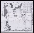
Air distances to Nanpo Shoto
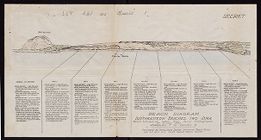
Beach diagram : Southeastern beaches, Iwo Jima
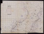
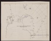
Intelligence Map : Nansei Shoto, Okinawa Gunto
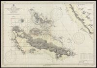
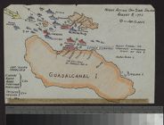
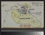
Guadacanal and Florida Is. with a portion of Malai...
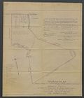
Map of Property of North Carolina State Highway & ...
Ownership map of proposed Cherry Point Marine Avia...
Track Chart of USS Pine Island (AV-12)
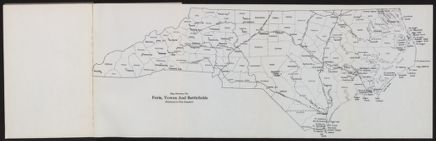
Map showing the forts, towns and battlefields ment...
Eastern Craven County North Carolina Highway Map (...
Eastern Craven County North Carolina Highway Map (...
Eastern Craven County and Carteret County, North C...
Eastern Craven County and Carteret County North Ca...
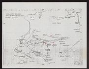
The approach and air searches, dog day, operation ...
Night action off Savo Island, August 8, 1942
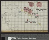
Enemy contacts, Oct. 14
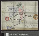
Fetlock Operation, Oct. 2, 1942
Operation Pestilence of Aug. 7, 1942 South Pacific...
USS Burns track chart